
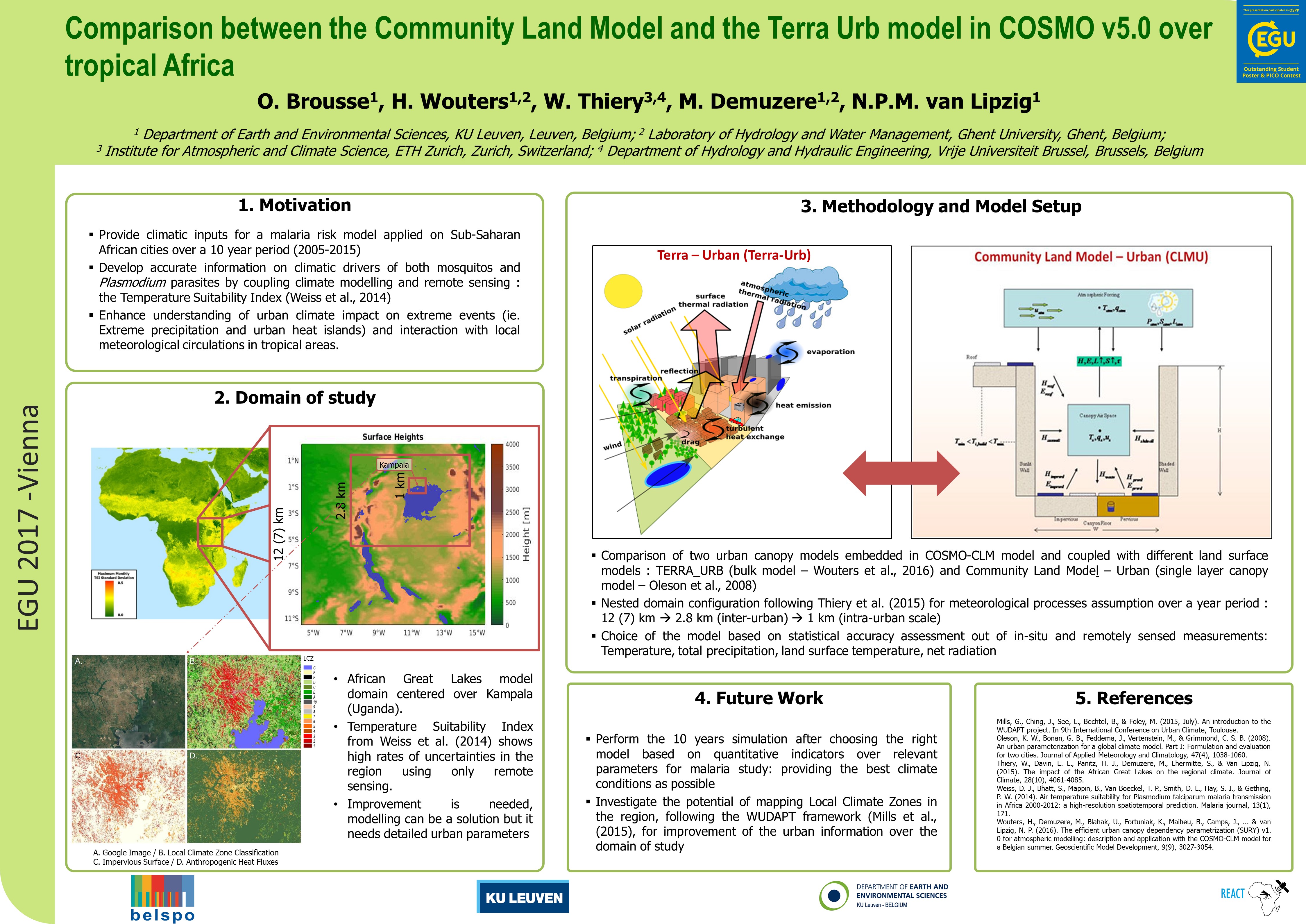
The urban climate model, which is based on the CCLM model (Rockel et al., 2008), exhibits good performance over equatorial Africa (Akkermans et al., 2014; Thiery et al., 2015). Recently, a new urban climate model TERRA-URB (Wouters et al., 2015) was developed. This urban model distinguishes itself by the very few parameters necessary compared to other ‘state-of-the-art’ land surface models. This is an advantage in the African context where generally less information on surface characteristics is available than in the western world. Urban climate model simulations will be performed for two selected cities, including Ouagadougou, at a resolution of 1 km for the period 2005-2015 at High-Performance Computational facilities of KU Leuven. Urban climate model simulations with the CCLM model will be performed for two selected cities, including Ouagadougou, at a resolution of 1 km for the period 2005-2015 at High-Performance Computational facilities of KU Leuven. Note that regional climate modelling at the kilometre-scale resolution is unprecedented for SSA. The high-resolution urban climate model simulation will be driven by a coarser-scale CCLM integration at 12-km grid spacing (0.11°), which in turn uses initial and lateral boundary fields from re-analysis archive of the European centre for medium-range weather forecasting (ERA-Interim; 79 km grid resolution). After successful testing of the model for several test cases, an 11-year simulation will be performed for the period of 2005-2015.
RS data collected will be translated into the input parameters of the urban climate model (NDVI, land use, imperviousness, albedo, emissivity, heat capacity, thermal conductivity and surface roughness), using the WUDAPT (The World Urban Database and Access Portal Tools) Local Climate Zones framework (Stewart & Oke, 2012; Bechtel et al., 2015, Brousse et al., 2016, Wouters et al., 2016) that cover only few African cities up to now. The model will be evaluated using data from WPs 4 and 5 (LST, cloudiness, precipitation) complemented with gridded products (latent heat flux, sensible heat flux, net surface shortwave radiation, net surface longwave radiation, thunderstorms) described by Thiery et al. 2015, as well as meteorological data collected during in intensive observation campaign in Ouagadougou (Holmer et al., 2012).
The advantage of urban climate modelling is the high temporal resolution (15 min), availability of data during cloudy conditions and information on the relation between LST and air temperature. On the other hand, RS is much more accurate than urban climate modelling, due to biases in the latter. For this reason, a methodology for synergetic use of satellite observations and the urban climate model will be developed, based on a rescaling of climate model output (see Van Tricht et al., 2016 for a similar methodology to derive a hybrid satellite-climate model data set for integrated liquid and ice water path). In a first step, cloud-free MODIS images from WP5 are used to rescale the urban climate model data, using a correction factor that is calculated from the deviation between satellite and model data. Secondly, the modelled LST within the different tiles (vegetation, build-up, water) are disaggregated to 100 m using the land-use map from WP3. Thirdly, this disaggregated field is re-scaled using cloud-free Landsat LST images. This yields a hybrid satellite climate model dataset at high-temporal (15 minutes) and spatial (100 m) resolution.
Existing relations (Weiss et al., 2014) between the LST and air temperature (the latter being more relevant for malaria) will be tested using the urban climate model data. If necessary, the existing relation will be revised to improve air temperature retrievals from remotely sensed LST. Subsequently, this relation will be applied to calculate air temperature from the hybrid satellite climate model dataset. Finally, a malaria Temperature Suitability Index (TSI) (Gething et al., 2011) will be created based on minimum and maximum air temperature.
In a similar way, a hybrid satellite climate model dataset for surface water will be derived, combining modelled water-storage capacity and the maximal wet surface with NDWI and Wetness Index.
Refererences
Bechtel, B., et al., 2015. Mapping Local Climate Zones for a Worldwide Database of the Form and Function of Cities. ISPRS International Journal of Geo-Information, 4(1), 199–219.
Holmer, Björn, Sofia Thorsson, and Jenny Lindén. 2012. Evening Evapotranspirative Cooling in Relation to Vegetation and Urban Geometry in the City of Ouagadougou, Burkina Faso. International Journal of Climatology, n/a – n/a. doi:10.1002/joc.3561.
Stewart, I. D., & Oke, T. R. (2012). Local climate zones for urban temperature studies. Bull. Am. Meteorol. Soc, 93, 1879-1900.
Van Tricht, K., Lhermitte, S., Lenaerts, J., Gorodetskaya, I., L'Ecuyer, T., Noël, B., van den Broeke, M., Turner, D., Van Lipzig, N. (2016). Clouds enhance Greenland ice sheet meltwater runoff. Nature Communications, 7, art.nr. 10266.
Weiss, D.J., Bhatt, S., Mappin, B., Van Boeckel, T.P., Smith, D.L, Hay, S.I. and Gething, P.W. (2014). Air temperature suitability for Plasmodium falciparum malaria transmission in Africa 2000-2012: a high-resolution spatiotemporal prediction. Malaria Journal, 13 : 171 DOI
Brousse, O., Martilli, A., Foley, M., Mills, G., & Bechtel, B. (2016). WUDAPT, an efficient land use producing data tool for mesoscale models? Integration of urban LCZ in WRF over Madrid. Urban Climate, 17, 116-134.
Wouters, H., Demuzere, M., Blahak, U., Fortuniak, K., Maiheu, B., Camps, J., ... & van Lipzig, N. P. (2016). The efficient urban canopy dependency parametrization (SURY) v1. 0 for atmospheric modelling: description and application with the COSMO-CLM model for a Belgian summer. Geoscientific Model Development, 9(9), 3027-3054.