
The Environmental Change model (EC) goal is to establish the environmental conditions associated to malaria transmission risk. The EC uses multiple temporal and spatial scales in order to contribute to the overall goal of the project in two fashions:
a) a cross section status of the environmental conditions integrating different spatial and temporal scales for the analytical snapshot identified by the EC (2005-2015); and,
b) a time-series analysis of environmental conditions from 2005-2015, to in order to account for trends, seasonality and in-between snapshot rapid change.
Within this model the goal has three tasks:
1) Generate customized environmental variables based on Low/Medium resolution datasets that integrate with the Urban Climate model.
2) Generate customized environmental variables that feed the epidemiological model.
3) Generate prediction models that use the temporal trends, and rapid change events data that identify areas of rapid environmental change associated to malaria incidence.
We will provide a long view of environmental conditions and how they change using coarse spatial but high temporal resolution imagery andl test summary variables describing changes in environmental conditions as potentially useful in the modelling of malaria transmission risk. We will replicate inputs used in the high resolution modelling of epidemiology including variables such as %vegetation, % built up, elevation, NDVI, distance to inland water in meters, LST, Precipitation.We aim at producing two sets of variables:
- ‘static’ equivalents at low/medium spatial resolution for a snapshot period (i.e., NDVI spatial only average at 1km for 2001-2015)
- temporal trend indicators for the whole time series
Spatio-Temporal trajectory detection and characterization of environmental conditions with proxies
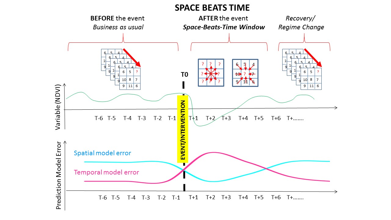
We will use the Space Beats Time framework (Benoit et al., 2017) to detect abrupt changes in spatio-temporal time series and for trajectory characterization. The general SBT methodological analysis steps are the following: 1) Predict variable at every pixel based on neighbouring observation values (Space-only model/parameter) and on past observation values (Time-only model/parameter); 2) Compare prediction performance between time-only and space-only models using an accuracy metric 3) Identify the SBT window that corresponds to the period of time when the Space-only model outperforms the time-only model. The SBT window corresponds to a regime shift i.e. a strong change in the process generating data (e.g. abrupt conversion to urban cover) or change in variability in space/time. This analysis is carried out at two different resolutions, 1km and 30m.
We will extract seasonality and summary variables for trends and variability for HTR/LSR time series. We will use the summary variables in every model time step at fine and coarse grained resolution. These summary variables allow the characterization of environmental and climate conditions and will feed directly in the epidemiological model. From the spatial distribution of these predictions (~1km resolution) we can extract clusters/hotspots of change of two types: 1) “slow change” 2) rapid change. In a next step, we can see if they relate to areas where malaria incidence is higher. That can then be compared across the 20 cities mentioned in inter-urban epidimiological model.
In this framework we assess if temporal trend environmental variables provide further insight compared to ‘static’ environmental variables produced for a snapshot, even at higher spatial resolutions (rate of change in NDVI vs NDVI at time t). We can calibrate/validate the model(s) with the malaria dependent variables at each snapshot.
References
Parmentier, Benoit, Marco Millones, Daniel A. Griffith, Stuart E. Hamilton, Yongwan Chun, and Sean McFall. "When Space Beats Time: A Proof of Concept with Hurricane Dean." In Advances in Geocomputation, pp. 207-215. Springer, Cham, 2017.